Community Corner
Udalls Cove Hot Spots
Preservation committee president suggests a few sites to see at the cove.
Udalls Cove Park is a narrow ribbon of wilderness that extends more than a mile north from Northern Boulevard to the open water of the cove that gives the park its name. As a nature preserve, there are only a few access points from which you can enter the park.
In this column and the next, I’ll provide some suggestions for those who are looking to spend an hour or two exploring this remnant of our natural heritage. The times noted are estimates of the minimum you’d need to get some appreciation of the area.
1. The Ravine, Part I [10 Minutes]
Find out what's happening in Bayside-Douglastonwith free, real-time updates from Patch.
If arriving by car, park on 244th Street just north of Northern Boulevard. This is the street that runs along the east side of the Zion Episcopal Church cemetery.
Walk east along Northern Boulevard a short distance past the Mobil gas station on the corner and enter on your left where you see the Udalls Cove Park sign.
Find out what's happening in Bayside-Douglastonwith free, real-time updates from Patch.
A trail winds through a lovely, young forest of evergreen and deciduous trees. These were planted in the early 1990s by Udalls Cove Preservation Committee volunteers on top of fill that was dumped in the 1960s before the area was designated a park. A couple hundred yards to the north, you will reach the end of the fill and find a steep drop-off into the ravine.
You’ll see where Gabler’s Creek emerges from its culvert. Feeling adventurous? You can climb carefully down into the bottom of the ravine and work your way north along the creek bed. But, be cautious because there isn’t an established trail.
The trail at the crest of the ravine turns left (west) and continues a few more yards until it emerges at the end of 44th Avenue in a small parking area behind the Douglaston Firehouse. Immediately to the north of the parking area and street is a split rail fence. Behind the fence is another restoration area where, from 2004 to 2008, the preservation committee worked to remove tons of concrete rubble that had been dumped 40 years earlier.
Volunteers also removed dense tangles of invasive vegetation and planted scores of native trees and shrubs. Explore this area and see the many trees and shrubs we’ve planted as well as discover the rock-lined water course and retention basin we installed to minimize erosion from storm water runoff. Just in front of the firehouse is 244th street, where your car is parked.
2. The Ravine, Part II [5-10 Minutes]
Drive north on 244th Street to the intersection of 44th Avenue, opposite the firehouse. Turn left onto 44th Avenue for one block and then right onto 243rd Street (immediately opposite the entrance to Zion Church).
Continue north on 243rd Street about three blocks to a dead end. You can enter the park here on an overgrown trail that leads into the bottom of the ravine just north of the Long Island Rail Road. This area is quite overgrown, but ambitious visitors can make their way around and see some extraordinarily large willow trees as well as Gabler’s Creek which here meanders across a sandy floodplain.
Until the 1960s, there were several cottages here that had been inhabited by descendants of African American settlers, many of whom made their living as oystermen. Their small community of homes was later bisected by the LIRR. The community included a tiny AME Church, which is now a private home standing near where your car is parked.
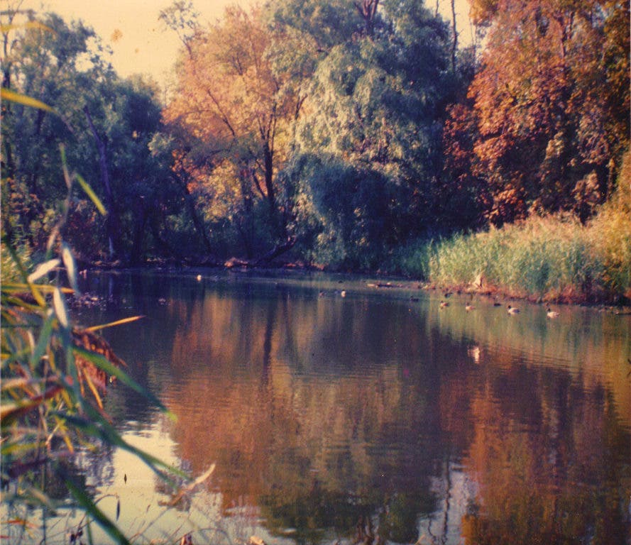
3. Aurora Pond [5-10 Minutes]
From Northern Boulevard, drive north on Little Neck Parkway until you reach the grade crossing over the LIRR tracks next to the Little Neck station. Cross the tracks and immediately turn left onto Sandhill Road.
Drive down a short hill and park at the bottom where the street curves towards the right. On the left, you’ll see Aurora Pond with its picturesque overlook. Watch for herons, kingfishers and ducks. Trails wind around the pond over a footbridge across Gabler’s Creek and through some of the adjacent woods.
In the next column, I’ll suggest a few more great spots to explore.